VENEZUELA

The North of Venezuela is dominated the the Andes mountains. The river running through the middle of Venezuela is called Orinoco River. Venezuela climate is 79 degrees Fahrenheit. One of Venezuela's major economy influence is oil, and is the fifth is oil exportation. The climate regions is a tropical savanna which has both dry and wet seasons and the dry seasons are are from January to April, and wet is from May to September.
Venezuela is located in South America and the countries that border Venezuela are Colombia, Brazil, Guyana and is by the Caribbean sea. Most of Venezuela's population is located near the Andes mountains. Venezuela core includes Lake Valencia and the capital is Caracas. Oil is the most used natural resource and the first discovery of oil was in the Maracaibo Basin. The most oil that comes from Venezuela is at Orinoco Basin, bellow the Orinoco Basin are the Guiana Highlands which separate Venezuela from the Amazon basin.
Colombia
Colombia boarders Venezuela, Brazil, Peru, Ecuador, Panama, Pacific Ocean,and Caribbean sea. Colombia has to keep peace with the country who owns the Panama Canal so Colombia can benefit from the Canal. The benefit is drug trafficking. Colombia first boarders took up Venezuela, Brazil, Peru,Ecuador and Panama and the country was Gran Colombia. Colombia is divided from three Andean mountain ranges western, central and eastern. The capital of Colombia is Bogota and has a population is about 12 million. The Magdalena River then separates the country, from the densely populated west and dense rain forest in the east.
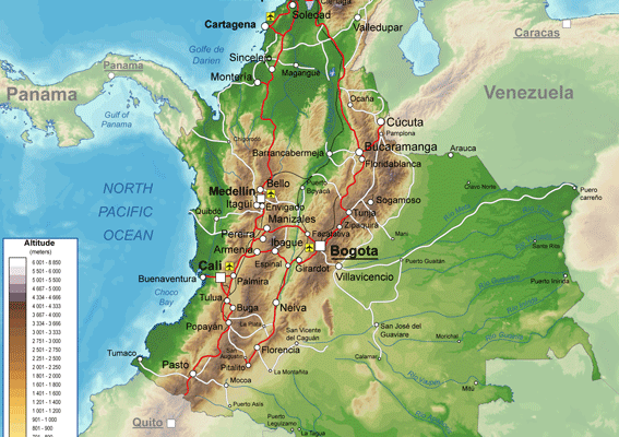
Colombia has both torrid jungles and snow capped mountains, The Andes interior is the heart of the county, Columbia’s major crop is coffee.
The Caucus River in the Andes.The landscape is amazing. The climate of Colombia is 75* F. and the climate zone is a tropical savanna with both dry and wet seasons favorable conditions for grasslands to grow.
The Caucus River in the Andes.The landscape is amazing. The climate of Colombia is 75* F. and the climate zone is a tropical savanna with both dry and wet seasons favorable conditions for grasslands to grow.
Argentina |
|
Argentina boarders are made by the Rio de la Plata drainage system the north then the Andes Mountains in the west. Argentina's core region is in the humid Pampas region. Buenos Aires is Argentina's heart of the agricultural center. The main crops are soy beans, wheat, and corn.West and south of the humid Pampas region are Lesley populated but has the region has oil. The Andes Mountains form a natural bearer with Chile. The only threat to Argentina's land is Brazil but other than that Argentina is safe from invasions.
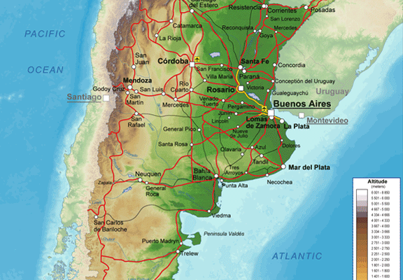
Argentina's climate Average annual temperatures range from 24°C (75°F) to 11°C (51°F) in Buenos Aries (sea level) and Córdoba (420m/1270 ft), and 24°C (75°F) to 8°C (46°F) in Mendoza (820 m/2484 ft). Argentina is from the subtropics along the northeastern border with Brazil.
Brazil |
|
Brazil boarders every country in South America besides Equator and Chile. Brazil is divided into four regions southeast, northeast, Amazon, and interior. The southeast is the most populated of the regions. The northeast is the poorest region in Brazil. The Amazon covers the northern part of Brazil and has a major port at the mouth of the river. Then the interior is the frontier land with much potential as a farming region. The Amazon also provides jobs and natural resources for Brazil but deforestation is threatening the forest.
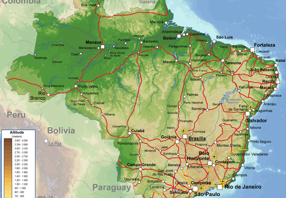
The capital of Brazil is Brasilia. Brazil has a humid tropical climate which gives Brazil a lush green environment. The average temperature from Brazil is about 79 degrees F and the major crop that Brazil exports from agriculture is Coffee, which Americans spend 18 billion dollars on a year.
Peru |
|
Peru is the third largest country in South America. Peru is separated in to three zone on the coast, the desert coast, and the Amazon region. The dessert coast is a almost rain less region. The Andean highlands is where most of the population is and the natural resources are silver and gold. The Amazon region is the most lush but is not the most populated region but the coca plant is a major crop in the region but this also brings drug cartels.

Since Peru has a diverse geography the weather and climate Peru can be diverse in each region. On the coast it can be warm and sunny. However the Andes can be cold and the jungles can be in between warm and cold, and the average temperatures range from 90 degrees F to 54 degrees F.
Chile
Chile is like a ribbon down the west coast of South America for over 4,000 kilometers. The democracy was rebuilt in 1989. exports have boosted the economy. Four regions make up Chile North, Central, Lake District, and Far South, the north has with the Atacama desert, the south is fertile and populous. Then The Lake district with the beautiful sites to see, and the south with the rain swept valley.
ECONOMY
ECONOMY
- Industry: Copper, other minerals, food, fish processing, iron and steel
- Agriculture: Wheat, corn, grapes, beans; beef; fish; timber
- Exports: Copper, fish, fruits, paper and pulp, chemicals
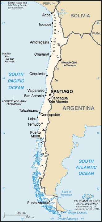
Chile's climate ranges from the south of Chile to the north. Most of the rainfall comes from the South with the cool and damp. Chile is in the temperate region and in the north is dry with the Atacama desert. Then in the central region the region has a Mediterranean climate, and the average temperature is 80 degrees F
Bolivia
Bolivia is a highland, which has many high plateaus which is called a Altiplano. Altiplano is a group of basin lying higher than 12000. The Andes in the west and southwest make up about a third on Bolivia. Its mostly desert-like in Bolivia.
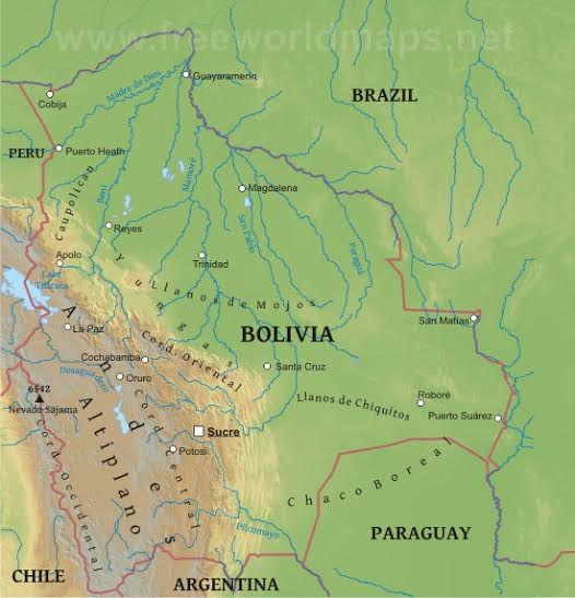
Bolivia has only two seasons rainy season and dry season is usually hot and humid is known to be windy in the lower elevations is tropical usual temp 16 to 20 degrees C. and has an average rainfall of 22.2 inches.
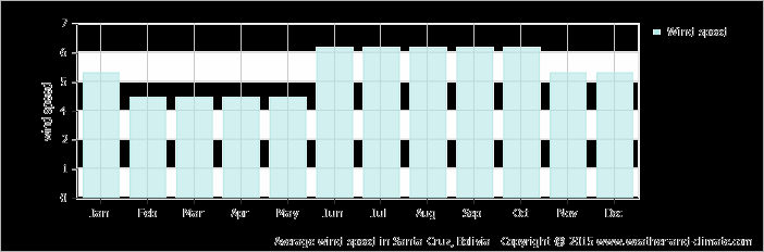
Average Wind Speed of Bolivia |
|
Ecuador
Ecuador is one of the smallest countries in South America. Ecuador is actually about the size of Colorado. Ecuador is called the center civilization since Ecuador is on the Equator. Ecuador actually gets the name from the Equator. Ecuador is inhabited by the Native Americans who have lived there centuries before. The people do the same activities as their ancestors did. Even though Ecuador is small country the people make the country big.

Ecuador is directly on the equator and gets sunlight from the equator 365 days a year. The capital of Ecuador, Quito, is less than 2 miles north from the equator. Quito’s climate is spring-like almost all year long. Ecuador is tropical along the coast, also is becoming cooler inland at higher elevation, and the temperatures range from 90 degrees F in the summer to 47 degrees F in the winter.
Fun Video
Ways to remember all of the countries in South America.
